General News
17 December, 2024
Firefighters continue to battle Grampians National Park blaze near Dunkeld
More than 520ha of land near Dunkeld has been burnt since 2pm.
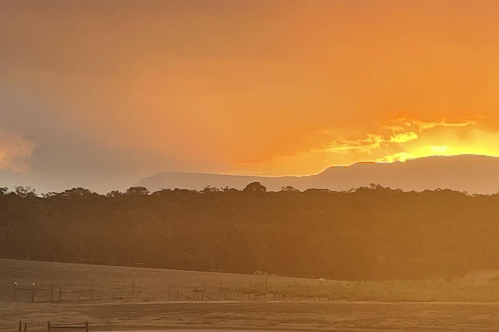
Update 9.25pm: Since a bushfire took hold, more than 520ha have burned in the Grampians National Park.
About a dozen firefighting crews and helicopters are battling the blaze about 20km north of Dunkeld.
Fortunately, the bushfire has not impacted private property.
Forest Fire Management Victoria has issued the following advice:
Road Closures:
Grampians Tourist Road is closed from Jimmy Creek Road to the intersection of Victoria Valley Road.
Yarram Gap Road is closed from Grampians Tourist Road to Moyston-Dunkeld Road.
Speed restrictions are in place along Grampians Tourist Road, south of Jimmy Creek.
Grampians National Park visitor information and closures:
The southern part of the Grampians National Park, including the Grampians Peaks trail is closed from Jimmy Creek to Dunkeld. The areas north of Jimmy Creek remain open.
Wannon Crossing campground is closed.
All walking tracks and campgrounds in the southern area are closed
The next update is expected at 10.30pm or as conditions change; however, this is the last update from us tonight.
To stay informed:
VicEmergency Hotline - freecall 1800 226 226
Tune in to ABC Local Radio, commercial and designated community radio stations, or Sky News TV.
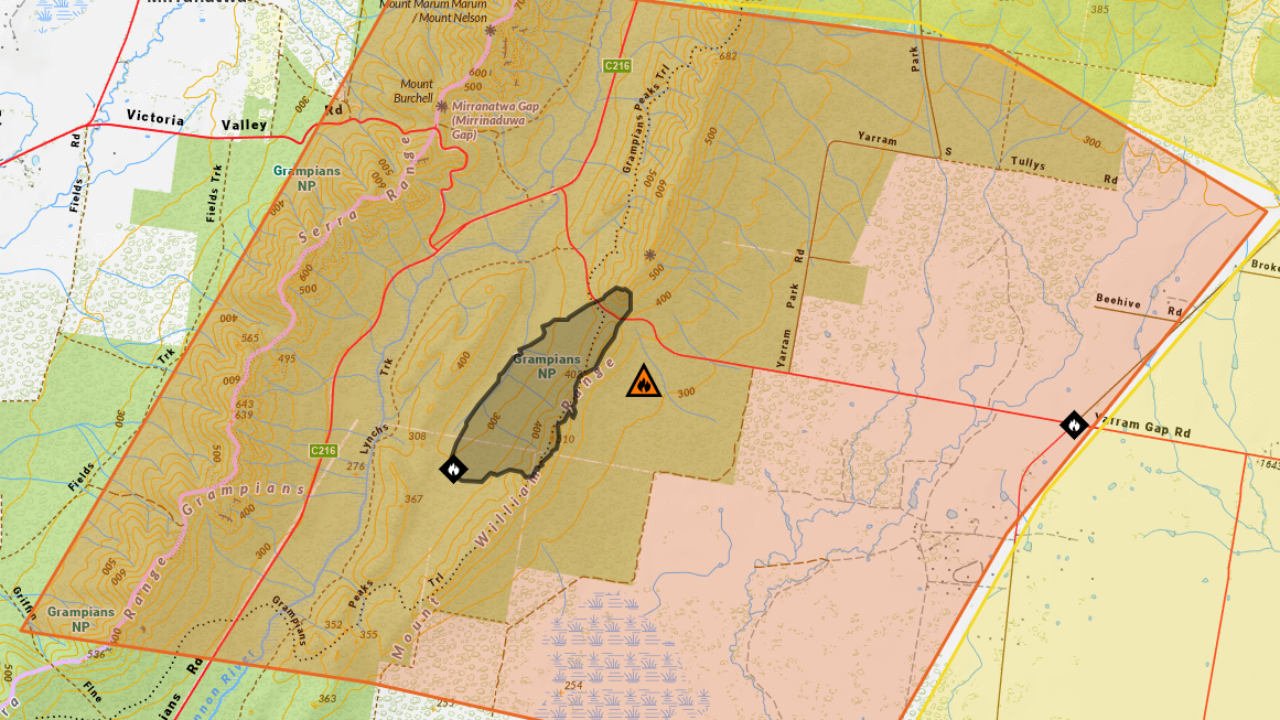
Update 6.50pm: The main bushfire north of Dunkeld has crossed Yarram Gap Road and continues to move in a north-easterly direction towards Mafeking.
Spot fires and embers are starting fires ahead of the main fire.
Emergency Services are warning residents in nearby affected communities to consider leaving now before conditions change.
Crews from Marnoo, Dadswells Bridge, Glenorchy & Riachella and District 16 have joined the strikeforce team in Willaura.
The next update is expected at 10pm or as conditions change.
Update 6.20pm: Residents northeast of the Yarram Gap Road have been told to stay alert and prepare to leave if the bushfire continues to spread.
People in Barton, Bellfield, Grampians, Jimmy Creek, Kia Ora, Mafeking, Mirranatwa, Moyston, Pomonal, Stavely, Watgania, Willaura and Willaura North were issued with the alert at 5pm.
Emergency services have said while there is currently no threat, you should stay informed and plan for what you will do if the situation changes.
A strikeforce made up of crew members from Pomonal, Ararat, Great Western and Moyston will assist the nine crews fighting a blaze on Lynchs Crossing Road in Mafeking and seven crews working near Dunkeld.
Almost 280 hectares have been burnt since 2pm.
Yarram Gap Road is closed from Grampians Tourist Road to Moyston-Dunkeld Road.
Smoke is visible from nearby communities and roads.
More to come.
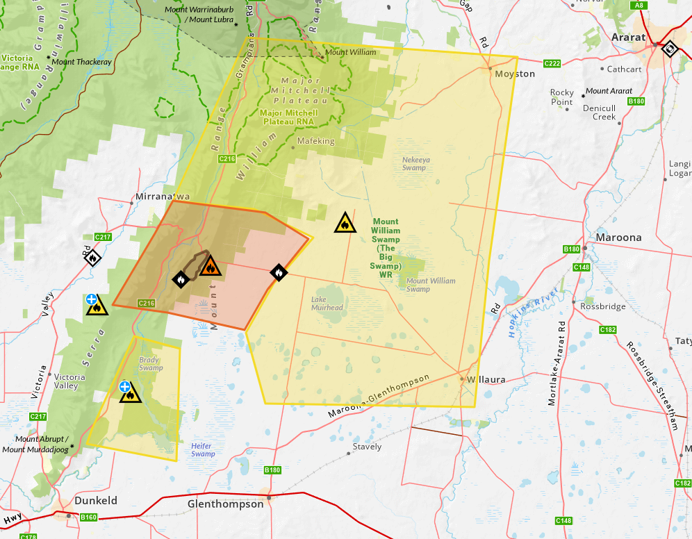
Earlier 4pm: Emergency services are responding to a bushfire in Grampians National Park on Tuesday, December 17.
A Watch and Act message has been issued for Grampians National Park near Yarram Gap Road at about 3.14pm.
This Advice message is being issued for Grampians, Jimmy Creek, Mafeking, Moyston, and Watgania.
Authorities say the bushfire is travelling from Lynchs Track in a north-easterly direction towards Yarram Gap Road.
Seven vehicles are responding to the bushfire which is not yet under control.
Yarram Gap Road is closed from Grampians Tourist Road to Moyston-Dunkeld Road.
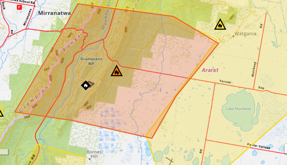
The next update is expected by 7.20pm or as the situation changes.
Members of the public can report incidents of sick, injured, or orphaned native animals anywhere in the state to Wildlife Victoria's 24/7 wildlife emergency response service at (03) 8400 7300.
If your property has been impacted by fire or storms and you have urgent animal welfare needs, please contact the VicEmergency Hotline on 1800 226 226.
An animal health team will assess livestock and provide advice to support your property's recovery.
What you should do:
Monitor changes to the situation. Increased wind speed, change in wind direction, smoke or poor visibility can indicate the situation is changing.
Protect yourself and your family.
If you are away from home, do not return.
If the situation changes or you feel unsafe you should leave:
Take your pets, medications, mobile phone and charger.
Many people have died trying to leave at the last minute during fires.
Travel to the home of family or friends that are away from the warning area or a safer location.
Impacts in your area:
Bushfires can spread quickly and are extremely dangerous.
Trees can be extremely hazardous during a bushfire or high winds. Avoid standing, parking or travelling in areas of fire affected trees.
Bushfires can start spot fires and embers can travel large distances ahead of the main fire.
Grampians National Park visitor information and closures:
Grampians Peaks Trail is closed from Jimmy Creek Road Trail Head to Dunkeld.
Wannon Crossing campground is closed.
All walking tracks and campgrounds in the southern area are closed.
VicEmergency advised community members to check multiple sources to stay informed:
www.emergency.vic.gov.au
VicEmergency Hotline - freecall 1800 226 226
VicEmergency app
Facebook or Twitter (#vicfires)
Tune in to ABC Local Radio, commercial and designated community radio stations, or Sky News TV.